


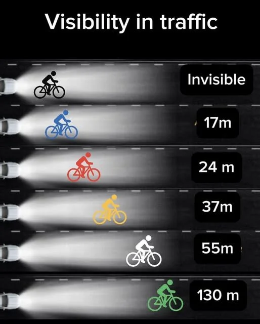
Wear bright colours whilst out cycling …. it may save your life. Black is not a safety colour.
NSW SCHOOL TERMS ... AND motor TRAFFIC FLOW PEAKS
When the Schools are in term the motor traffic is usually 10% heavier and its much less pleasurable for a training ride.
Naturally the earlier you can get out for a ride the more enjoyable it will be.
Saturday is by far the worst day for a pedal and being home by 9.30am is essential.
The Spit Bridge is best used from the western footpath via the Seaforth shops approach.
Be careful if you are riding towards the City as the Bridge footpath itself can be very slippery after rain.

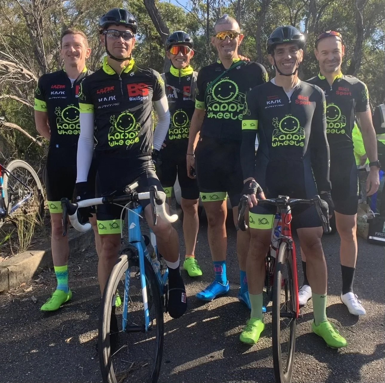
Bicisport GROUP Rides
BiciSport conducts regular Group rides (refer the News section of this website).
GROUP Ride Code of Conduct
When BiciSport members are riding on public roads they need to develop adequate cycling skills for the safety of themselves and other road users.
Team members must abide by the road rules just as motorists do.
Cyclists must stop at red traffic lights. When the cycling bunches are larger, riders may have to separate to obey the red traffic signal, so communication between riders is very important.
Refrain from following poor cycling conduct (especially when wearing the sponsor`s team clothing). Understand that your cycling conduct is an example to other cyclists in the group.
Assist the group safety by alerting following riders of dangerous potholes or debris on the road. You can alert other riders by pointing to the pothole, or simply yelling out a word of caution.
BiciSport team clothing is a very smart looking kit - it is not compulsory to wear BiciSport team clothing on group rides.
HANDY RIDE Tips
Some tips to save your skin when group riding or racing in a bunch -
Clothing
Black is not a safety colour. Be seen, be safe.
Predictable
sudden changes of direction should be avoided
Don`t Overlap Wheels
for obvious reasons
Maintain a Steady Pace
constant speed reduces the chance of an accident
Communicate
good communication can alert other cyclists to potholes or red traffic lights
Audio Devices
don`t ever ride with an IPod (you can`t hear the traffic)
Hand Positioning
never grip the handlebars with an `open` palm - always wrap your thumb around the back of the handelbars. Open palm riding is dangerous if you hit a pothole
What happened ?
look where you`re going, not where you`ve been - don`t look behind you in a bunch
Gear Changes
whenever you change gears, or search for a water bottle, NEVER look down (unless you`re very experienced you will drift off a straight line, and cause issues for those cyclists behind you)
A Straight Line
always bend your elbows slightly to steer the bike with your hands/fingers. Stiff or straight elbows means your collarbone does the steering (if that`s the case, you`ll never ride a straight line in a bunch).
Insurance Cover
If you are group riding and want the benefits of the insurance cover, then it is highly recommended you maintain a formal training log approved by your coach (and always in writing [via email]).
Daylight Saving Time PERIODS
NSW State Government policy is that daylight saving time will run from the first Sunday in October until the first Sunday in April
BICISPORT GROUP RIDES
BiciSport conducts regular group rides and these rides are updated (for the next week) in the News Section of this website every Monday morning.
Sydney Olympic Park Homebush - Sunday Ride
Hosted by Lidcombe Auburn Cycling Club around the Sydney Olympic Park region offers numerous cycling options. Rides can alternate around the Olympic venues themselves or you can venture down to the Parramatta River bike paths.
Sydney Olympic Park rides operate Tuesday, Wednesday and Sunday.
The Sunday Ride leaves from the Parramatta River Wharf at 7am (northern end of Hill Street) then does 8k laps around Sydney Olympic Park. Further details on the Lidcombe Auburn website at www.lacc.org.au
La Reve, Il Presidente, Guns & Roses Rides
Hosted by Northern Sydney Cycling Club there are several well organised training rides based on the Hornsby & Duffys Forest region. Further details are on the Northern Sydney website at www.northernsydneycyclingclub.org.au
Waratah Masters St Ives `Coffee Ride`
Hosted by Waratah Masters Cycling Club the ride departs corner of Mona Vale Road and Stanley Streets St Ives at 7.30am on Tuesday & Thursday.
East along Mona Vale Road to Terrey Hills (7.50am-8.00am) - splits into a fast & slow group
down through the steep side of Akuna Bay, climb out of the shallow side of Akuna Bay to the West Head Rd intersection (at 8.45am), wait & regroup, then climb McCarrs Creek Road, regroup again at the top, then west along Booralie Road to Duffy`s Forest.
U-turn at Duffy`s Forest and return to the St Ives Shopping Centre via Mona Vale Road.
Coffee is at St Ives Shopping Centre at 9.30am.
Centennial Park Training Bunches
Centennial Park is a popular training venue in the centre of Sydney.
Several training ride options (all on the flat 4k circuit going clockwise)
Tuesday & Thursday morning all year round - from 5.45am until 7.15am-7.30am.
Monday, Wednesday & Friday mornings - Group Molteni from 8.15am until 9.30am then coffee at The Spruce Goose Cafe
Afternoon training rides -
Summer rides are Wed/Thurs/Friday and the group forms up from approximately 4.15pm until 6pm. Thursday is the much harder day.
Winter the rides are Tues/Wed/Thurs.
Bunch sizes are restricted to 16 riders per bunch & 30kph monitored by the CP Park Rangers.
Best days are Monday to Friday, but Saturday is overly congested (especially before lunch) and Sunday can be a lottery (either very good or very bad with congestion).

M7 Cyclepath - Northern end at Bella Vista

M7 Cyclepath - offers safe cycling for 40k each way (80k in total) but caution needs to be taken through the numerous corners. The corners are mostly 'blind' with poor line of sight and extreme caution is needed especially if wet.
M7 Motorway Cycle Path
FROM Bella Vista (Glenwood) to Bringelly & return
The M7 cycle path offers some of the best car free cycling in Sydney.
The cycle path is 40k in length (each way), so from Bella Vista/Glenwood to Prestons and is an 80k round trip.
There are no toilets on the M7 cyclepath
The only water stop is near the Lighthorse Interchange (western side of the cyclepath)
The southern (Prestons) end can easily flood in heavy rain and the M7 cyclepath may be closed from time to time
Starting Finish Locations
Option 1 - Northern End - Fairmont Circuit @ Glenwood (pedal the 300m to the M7 Cyclepath)
Option 2 - Southern End - McDonalds Restaurant @ Prestons
Option 3 - The Middle Depart - depart @ Rooty Hill Railway Station
Facts
40k each way from Bella Vista to Prestons
Road conditions are good, but the road is narrow & there are numerous corners
There are no coffee or food stops & the only water available is near Wallgrove Rd intersection
Toilets & Food are available at the southern (Bringelly) end at the BP Service Station/McDonalds at Prestons
Good Aspects
Car free & comparatively flat to undulating (only gradual climb is at Cecil Hills)
Excellent lighting for night riding
Riding groups best restricted to less than 6 riders
Excellent ride options into Moonrise Ridge
Turn off the M7 Cyclepath at the Sydney Equestrian Centre and proceed into the Sydney Parklands
Moonrise Ridge is a 45 minute detour off the M7 Cyclepath
Southern section from Wallgrove Rd to Prestons is more pictureque
Best days - Monday to Friday
Poor Aspects
Road is narrow & particularly narrow on the corners
White lines on the cyclepath are slippery in the wet (avoid at all costs)
Corners are numerous and need to be always taken with extreme care
Electricity service grates are -
numerous and very slippery when wet
often located at the apex of corners and need to be treated with extreme caution
No coffee or food stops (so take 2 full bidons + food gels at all times)
Worst days - Saturday & Sunday (too many cyclists)
WHERE TO RIDE ON THE NORTHSIDE
McCarrs Creek SPeed Bumps - Be Warned
Installed in 2020 probably some of the worst cyclist road engineering ever installed with 22 speed bumps installed from Church Point to the Ku Ring Gai National Park.

NORTHERN BEACHES - HINTS FOR A SAFE LOCAL RIDE
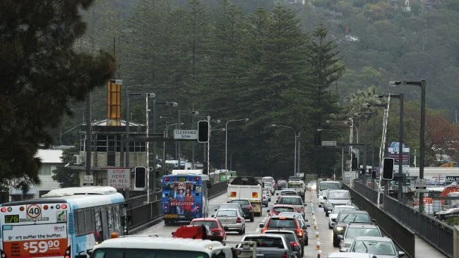
`The Saturday Traffic Crush` ...
The Sydney Morning Herald quoted -`Saturday - Sydney`s one big car park`, the article went on to analyse the Saturday traffic crush. The RMS statistics indicated what cyclists have known for some time -
the worst days for Sydney traffic congestion is Tuesday mornings and Friday afternoon
the Saturday morning peak starts at approximately 8.30am, and is in full swing by 9am
was consistently high all day Saturday (unlike mid week days)
nearly 50% of Saturday trips were for visits, entertainment or sport
Saturday car trips along Military Rd (through Mosman) now exceed mid week numbers !
the Saturday cycling strategy - get out & back as early as possible to maximise the enjoyment. Certainly, any return journey after 9am will become something less than pleasant.
PITTWATER RD (MONA VALE TO SEAFORTH)
The Saturday experience is best served before 8.30am, as the Saturday traffic crush through Collaroy, Dee Why and Brookvale becomes very heavy from 9.00am.
The recommended McCarrs Creek loop is - Pittwater Rd going north, then veer left onto McCarrs Creek Rd at Mona Vale, through Church Point, and return via Forest Way and Allambie Heights Rd (down to Manly Vale). The new SupaCentre Complex at the corner of Forest Way/Mona Vale Rd attracts considerable traffic on a Saturday after 9.00am, and Forest Way is most unpleasant near the Warringah Rd interchange after 9.00am.
ALTERNATIVES TO PITTWATER ROAD INCLUDE -
Collaroy Plateau Loop (if going north) - use South Creek Road towards Cromer, onto the Rose Avenue climb to the top of Collaroy Plateau. Caution needs to be exercised on the Veterans Parade descent towards Narrabeen.
Ocean Street Narrabeen Loop (if going north or south) - use Ocean Street along the Narrabeen Peninsula, across Narrabeen Lakes bridge, then Sydney Road towards Mona Vale Hospital.
The traffic congestion between Narrabeen Bridge & Powderworks Road is heavy (in both directions) in the morning & afternoon peak, and the Ocean Street Loop is the best alternative during these peak times.Dee Why Beach Loop (if going south) - turn left into Howard Street, then Griffin Road, over the Dee Why Beach climb, then beside Curl Curl Beach, Carrington Parade, then Harbord Diggers Club and Freshwater Beach. Avoid the Warringah Mall area at all costs.
SPIT BRIDGE DESCENT (SEAFORTH SIDE) ... THEN THERE`S MILTARY RD MOSMAN
Alternatives to Spit Bridge include using Battle Boulevarde (via the Seaforth shops), and use the western footpath across the Spit Bridge (note - the Bridge footpath itself can be very very slippery when damp or wet when you`re heading south - so don`t jump on the front brakes, as a crash will result).
Military Rd through Mosman is unpleasant in a car on Saturday after 8.30am, let alone on a bike. There are several parallel route alternatives to Military Rd, both on the eastern and western sides of Military Rd. Recent RMS statistics confirm more car trips along Military Rd through Mosman on a Saturday than mid week.
The Saturday strategy seems to be - get out early, and be home before 9.30am at the latest.
FOREST WAY-WARRINGAH ROAD-ALLAMBIE HEIGHTS ROAD AREA
Without doubt the most dangerous bit of cycling real estate on the northside. Warringah Road (in either direction), from Forest Way to Allambie Heights Road, is a total no go zone at all times.
ALTERNATIVES TO WARRINGAH ROAD INCLUDE -
Warringah Aquatic Centre Loop - using Aquatic Drive towards the Warringah Swimming Centre, turn right through the Aquatic Centre carpark, along a narrow pedestrian footway over the Wakehurst Parkway footbridge, then turn right into Bantry Bay Rd, left into Fitzpatrick Ave, right into Karingal Cres, right into a tiny footpath opposite Akora Street, and then over the Warringah Rd footbridge (and onto Forest Way itself)
Morgan Road Loop - cut across Warringah Road at the Government Road intersection, then use Oxford Falls Road, briefly onto Wakehurst Parkway going north, before turning left onto Oxford Falls Rd again, past the Optus Earth Station, climbing the steep Morgan Road climb to Forest Way.
WAKEHURST PARKWAY (NARRABEEN TO FRENCHS FOREST)
Wakehurst Parkway looks reasonably safe for cycling (with a wide side verge), but the Parkway has serious car accidents on a regular basis near the Deep Creek area (just near the narrow bridge).
The Parkway from Narrabeen to Frenchs Forest is best avoided at all times, and despite Pittwater Rd carrying a lot of traffic, the Pittwater Rd alternative is generally considered a safer option.
WAKEHURST PARKWAY (FRENCHS FOREST TO SEAFORTH)
Comparatively safer for training rides, and is a popular training route. When going south along the Wakehurst Parkway towards Seaforth, a good option is to take the first left when you approach Seaforth suburbia at Kirkwood Street, then loop through the back of Seaforth, using Judith & Manning Streets, past the Wakehurst Golf Club, onto North Balgowlah and towards Manly (crossing over the Burnt Creek Deviation at Kitchener Street)
Finally, the other total "no go zones" are Mona Vale Rd (from Terrey Hills to Mona Vale) past the Bahai Temple, and either side of Roseville Bridge. Both are major arterial roads carrying excessive amounts of traffic.

NATIONAL PARK ZONE
AKUNA BAY DESCENTS
The (steeper) Cottage Point Inn side has seen numerous crashes, especially on the bumpy, straight section of road 500m before the Cottage Point Inn turnoff - extreme caution is required at all times on what looks like a totally innocent straight stretch of road. This dangerous Cottage Point Inn area now has had some of the bumps `smoothed` and `caution` signs erected on the left hand side of the road. However, the road surface near the Cottage Point Inn turnoff remains of very poor quality.
The right hand corner half way down the descent (with the rock wall on the left) has claimed numerous victims especially in the wet.
The (flatter) descent into Akuna Bay is from the West Head side - the road is bumpy in parts, with one right hand corner half way down requiring particular caution.
BOBBIN HEAD DESCENTS (BOTH MT COLAH & TURRAMURRA SIDES)
This popular training road looks pretty straight forward, but the road edges of both descents have degenerated considerably over recent years.
Riders regularly go "rubber side up" on the steeper Mt Colah side, and more so than ever there seems to be `just one proper line through the corners`. The last left hand corner into Bobbin Head itself is particularly dangerous (especially if damp). Local "boaties" regularly drop oil on the road from towing their boats, and the road is often littered with branches after a heavy wind.
The descent on the Turramurra side is comparatively safer than the Mt Colah side, but the road is still very bumpy in parts, especially through the corners, and the road edges are poor.
The Turramurra side was resurfaced in late 2024
WEST HEAD ROAD
The West Head Rd was resurfaced in August 2009, and the loop is just 14k each way (28k back to the Akuna Bay road intersection), with 11 climbs in total - 5 climbs each way plus the steep Commodore Heights climb.
This is possibly the best cycling real estate in Sydney, especially after the new road surface has gone down.
The very end of the West Head loop is the only serious traffic blackspot - the steep descent into Commodore Heights is greeted with a near impossibly sharp right hand bend with no camber ... the descent into Commodore Heights is incredibly quick, but the road narrows and the right hand bend has absolutely no camber. This right hand corner has claimed numerous victims over the years, and the steep descent needs to be taken under `full brakes` or a major accident is a certainty at the right hand corner.
Northside club racing events avoid this nasty right hand corner altogether (club races do a u-turn at the NP&WS Rangers Station at the Resolute recreation area).
Mobile phone reception on the West Head Rd is very poor & be mindful of wallabies & kangaroo`s crossing the road.
CHURCH POINT to MCCARRS CREEK AREA
McCarrs Creek Rd is hugely popular with cyclists, especially on weekends.
The McCarrs Creek descent towards Church Point is not particularly dangerous, but can be narrow in parts. When descending towards Church Point, be mindful of oncoming motor vehicle traffic moving out to overtake cyclists climbing back the other way - especially Saturday & Sunday mornings. The road surfaces & edges east of Bayview are sub standard, with numerous potholes & uneven surfaces.
OTHER NORTHSIDE AREAS
GALSTON GORGE-BEROWRA WATERS FERRY DESCENTS
Galston Gorge is best avoided at all times except for early on a Sunday morning.
Neither side of the Gorge is particularly dangerous but heavy traffic (especially during mid week peak hours and Saturday) ensures the road should be best avoided - best option is to go via Berowra Waters Ferry from the Berowra side.
The Berowra Waters descent from the Berrilee side requires care, especially after the road narrows approximately 2 kilometres from the top.
CALGA
Three rock quarries operate `6 days per week`near the Calga interchange at Jones Road, Peats Ridge shops and at Kulnurra (5k west of Peats Ridge towards Wollombi).
The quarry trucks can pose a serious safety issue if you are training on the Calga-Peats Ridge Road, and nearby Wisemans Ferry Rd at Somersby, especially from Monday to Saturday.
Sunday is the best day by far.
MOTORCYCLISTS ON THE OLD PACIFIC HIGHWAY
From Cowan to Calga is a major safety issue, especially on Sunday after 8.30am. To improve road safety the Old Pacific Highway is now a 80k speed limit zone from Cowan to Brooklyn, and a 60k speed limit from Mooney Mooney to Calga.
However, these speed zones don`t stop random acts of total motorcycle stupidity (several white crosses along the Highway verges are testimony to their behaviour). Pedal cyclists are well advised to ride single file on certain sections of this Cowan-Calga road to allow room for considerate motor cyclists to pass safely (and give the crazies even more room).
Police regularly patrol this stretch of road from Cowan to Mt White. The Old Pacific Highway through the small Cowan village has been reduced to one lane each way, and a cycle lane has been provided.
NORTHSIDE TRAFFIC BLACKSPOTS TO AVOID
RED TRAFFIC LIGHTS & CYCLING ACCIDENT STATISTICS
The issues with ignoring red traffic lights as a cyclist are simple - you`ll get killed eventually (that is a certainty), and the period before you get killed gives all the motorists a really poor public relations experience. The additional downside - all done while wearing your sponsors team clothing. In short, its a dumb thing to do.
Some recent government statistics on cycling fatalities -
60% of fatalities are deemed the cyclists fault
most fatalities are between 3-6pm
most dangerous day is Wednesday
30% of fatalities occur at intersections
ROAD SAFETY - HOW AWARE ARE YOU ?
How aware are you of your safety when you go for a training ride or you need to do some hard interval efforts on your favourite hill ?.
Are you aware that the road you`re on maybe isn`t the best place to be at that particular time of day ?.
As an example ... riding along Military Road through Spit Junction maybe safe on a Sunday morning at 7am but could be considered sheer cycling lunacy at 11am on a Saturday morning. So, when you jump on your bike next time please give the safety aspect your full attention ... is this road bike safe at this time of day ? ... am I wearing bright & easy to see bike safe clothing ? (black jerseys make no sense full stop) ... are the roads slippery and greasy from overnight rain ? ... if it is greasy where are those slippery white lines to trap you out ? ... should I use a flashing tailight even in the daytime if cycling on heavily trafficed roads ?
NORTHSIDE BLACKSPOTS
Sydney traffic is verging on the totally insane, with January the best month (everybody has gone away on holidays), with February & March the worst (everybody is back).
Midweek - Wednesday the most dangerous, Thursday & Friday afternoon peaks are the most hectic, and Saturday is the low point of the week (with traffic the most hectic)
Please email bicisport1@gmail.com if you become aware of the latest Northside BlackSpots
McCarrs Creek Road Church Point SpeedBumps
Dangerous, over engineered, be careful, 22 mistakes in just 4 kilometers
KISSING POINT RD TURRAMURRA - TOP SECTION
The recent tragic cyclist fatality on the top steep section near the Pacific Highway always merits the most extreme caution. Cyclist speeds over 65k are easily achieved near the top which then causes issues further down the climb with motor traffic.
BOBBIN HEAD CLIMBS - RIDING TWO ABREAST
As reported in the NorthShore Times there has been complaints about cyclists riding two abreast on both sides of Bobbin Head. Unclear if the complaints are from local residents (which appears unlikely) or drivers using the National Park as a rat run shortcut to avoid Hornsby. Either way the issue has appeared in the local northside media.
COWAN TO CALGA (OLD PACIFIC HIGHWAY) - MOTORCYCLE MADNESS
This section of road is now a designated 80k zone (from Cowan to Brooklyn), and a 60k zone (from Mooney Mooney to Calga) to primarily prevent motorcycle fatalities, but the old Pacific Highway remains very popular with motorcyclists for the purposes of undertaking random acts of total stupidity (especially from 8.30am on a Sunday morning).
The corners approaching Mt White now have high quality smooth bitumen to prevent motorcyclists from falling off, but this seems to just make motorcyclists go faster, and fatalities continue.
Pedal cyclists are best advised to go single file wherever appropriate & give the considerate motorcyclists room to overtake safely.
WEST HEAD ROAD - WALLABY WATCH
Cyclists have been seriously injured after collisions with wallabies on the West Head Road.
You need to be very unlucky, but it happens more times than you think.
WEST HEAD ROAD AT COMMODORE HEIGHTS ... THAT RIGHT HAND CORNER
A long term black spot and still extremely dangerous, especially with the new faster road surface.
The right hand corner at the end of the Commodore Heights dipper can be fatal.
FOREST WAY - MID WEEK `B DOUBLE` TRUCKS
If you ever want to be scared to death, then try riding down Forest Way mid week.
The single bike lane is not much comfort with heavy industrial traffic now stampeding down Forest Way. The 80k speed limit looks optional, and the sight of big `B Double` trucks tailgating each other past the Belrose lights is simply scary. These trucks have absolutely no regard for cyclists in the bike lane.
The weekends are thankfully much safer, but mid week is now extremely dangerous
PEATS RIDGE/CALGA - POTHOLE PARADISE
Numerous potholes on the road from Peats Ridge to Calga is a shocker - the rain & quarry trucks have ruined the road on both sides.

Towards Akuna Bay in the Ku Ring Gai National Park

McCarrs Creek Road Speed Bumps

McCarrs Creek Rd Speedbumps